
Video and Sensor Data Integration
Connecting Video, Sensor Data, and Remote Monitoring in One System
1. Overview
In infrastructure and industrial monitoring, video footage provides visual information about site conditions, while sensors deliver quantitative measurements of structural, environmental, and equipment parameters.
Integrating video with sensor data helps operators understand not only what is happening at a monitoring site, but also the measurements associated with those conditions.
Hu Entropy Tech provides industrial RTUs, data acquisition equipment, and video and IoT integration hardware to support the connection of field sensors, cameras, and remote monitoring platforms.
This approach can be applied to dam safety, flood warning, slope monitoring, mining safety, industrial facilities, and other distributed monitoring applications.
2. How Video and Sensor Data Integration Works
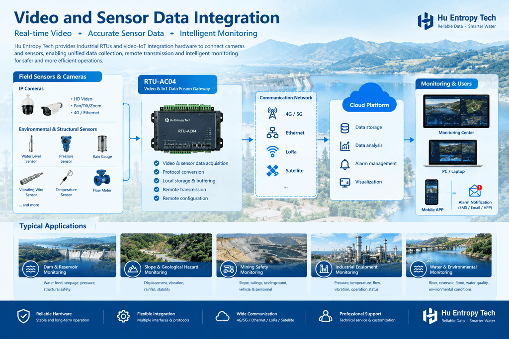
A typical integrated monitoring system connects field sensors and cameras to data acquisition and communication hardware. Sensor measurements and video streams are then delivered to a monitoring platform through supported interfaces and communication networks.
Field Sensors + Cameras → Data Acquisition & Video Gateway → Communication Network → Monitoring Platform → Visualization & Alarms
Depending on the system architecture, the platform can display sensor measurements alongside relevant video footage, allowing operators to review numerical data and visual conditions within a unified monitoring workflow.
For example, a rise in water level can be reviewed together with video from a nearby river monitoring station. Similarly, slope displacement measurements can be assessed alongside camera footage of the monitored area.
3. Key Applications
Dam Safety and Water Management
Integrate water level, rainfall, seepage, and other compatible sensor measurements with camera footage from dams, reservoirs, rivers, and flood monitoring stations.
This combined view helps operators review changing water conditions and assess potential risks with additional visual context.
Slope and Geological Hazard Monitoring
Combine displacement, pore pressure, rainfall, and other geotechnical measurements with video monitoring of slopes, embankments, and potentially unstable areas.
The integration supports more informed review of abnormal measurements and site conditions.
Mining Safety Monitoring
Connect monitoring instruments and video systems across open-pit mines, tailings facilities, and other mining areas.
Centralized visualization can help operators review sensor readings and site activity together, subject to camera coverage and system integration.
Industrial Equipment and Facility Monitoring
Combine compatible equipment measurements—such as pressure, temperature, flow, and vibration—with video from industrial sites.
This provides additional context for investigating abnormal operating conditions and coordinating maintenance activities.
4. Video Gateway and Sensor Data Integration
Hu Entropy Tech offers industrial monitoring hardware, including the RTU-AC04 Industrial Video and IoT Data Fusion Gateway, designed to support the integration of video and field data in monitoring systems.
Depending on the equipment configuration and integration requirements, relevant capabilities may include:
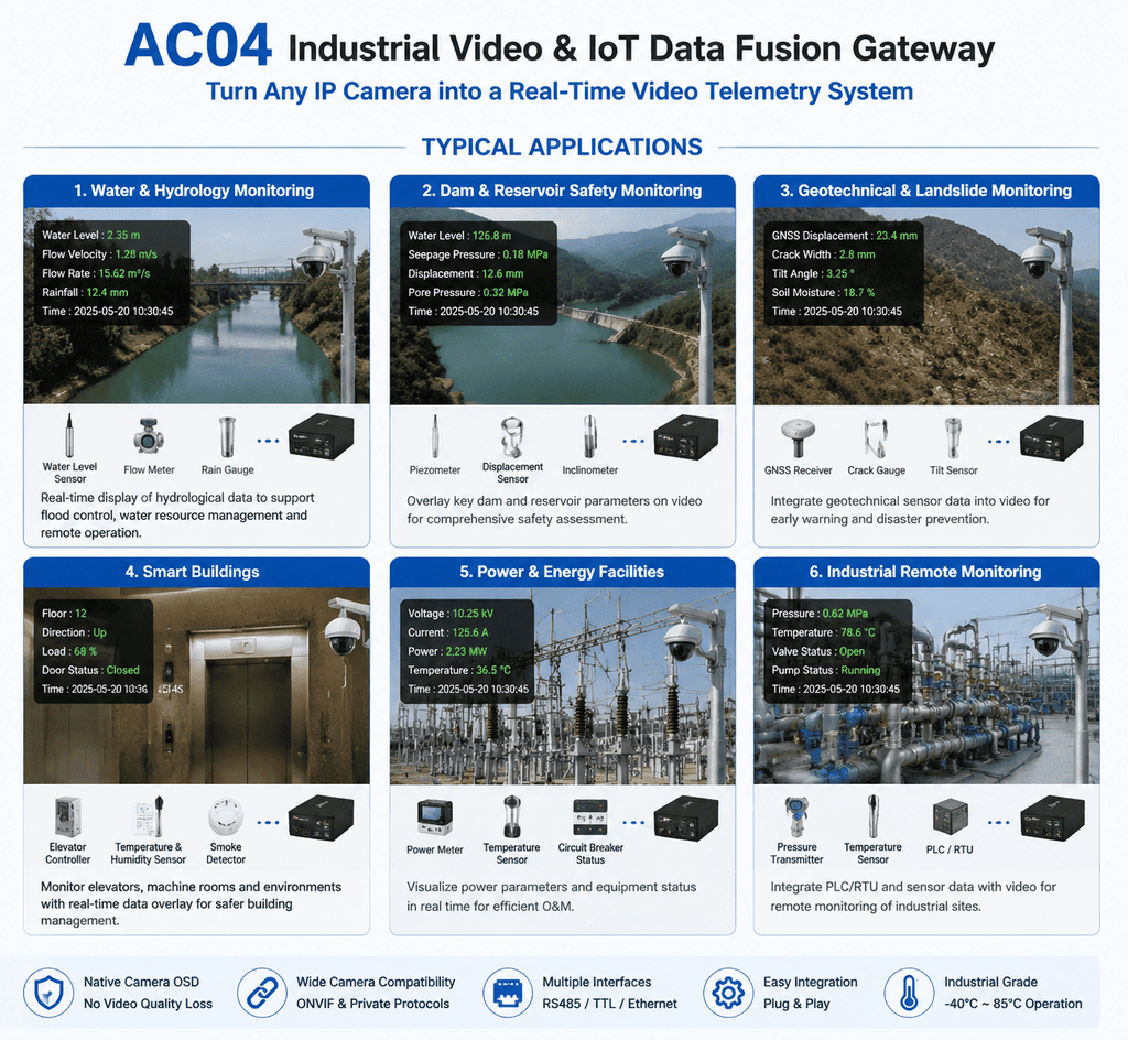
- Integration with supported IP cameras and video systems
- Acquisition of sensor data through supported industrial interfaces
- Communication with compatible field instruments and controllers
- Integration with supported protocols, including Modbus and customized interfaces
- Presentation of sensor data alongside video, where supported
- Connection to wider monitoring systems and platforms
The RTU-AC04 supports integration with specified camera systems and compatible interfaces. Camera models, protocols, data sources, and display functions should be verified against the requirements of each project.
5. Benefits of Integrated Monitoring
Better situational awareness
Operators can review quantitative measurements and visual information together, reducing the need to switch between separate systems.
More efficient incident investigation
When an abnormal measurement is detected, relevant video can provide additional context for reviewing site conditions.
Centralized monitoring
Integrated systems can bring data from multiple sensors and cameras into a common monitoring workflow.
Flexible system integration
Industrial gateways and data acquisition hardware can help connect field instruments, cameras, and existing platforms, subject to interface and protocol compatibility.
6. Hu Entropy Tech Integration Hardware
Hu Entropy Tech provides industrial RTUs, vibrating wire data acquisition units, multi-channel acquisition equipment, and video and IoT integration hardware for engineering and industrial monitoring applications.
We support hardware integration for system integrators, engineering companies, equipment manufacturers, and OEM/ODM partners.
When planning a video and sensor integration project, important considerations include camera compatibility, sensor interfaces, communication protocols, network bandwidth, data synchronization, power supply, and integration with the existing monitoring platform.
Looking to integrate video and sensor data into your monitoring system?
Contact Hu Entropy Tech to discuss your camera interfaces, sensor requirements, communication protocols, and OEM/ODM hardware needs.
Website: https://huentropytech.com/
Digital Twin for River Basin Management
Integrated Water Monitoring | Remote Data Acquisition | Video Surveillance | Intelligent Early Warning
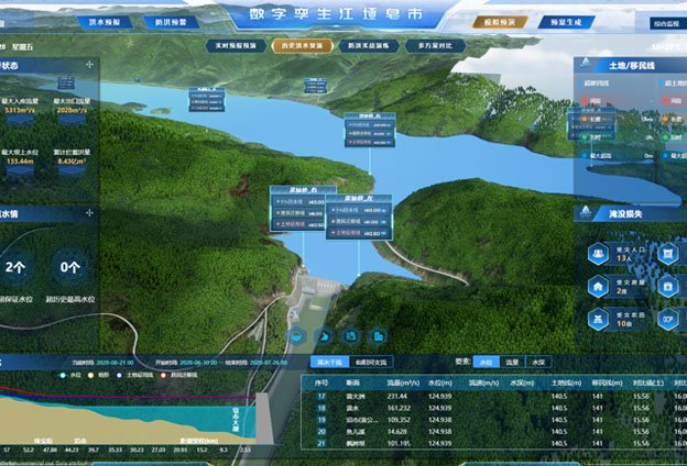
1. Project Overview: Yangtze River Basin Digital Twin
The Yangtze River Basin Comprehensive Water Monitoring System is designed to establish an integrated monitoring network covering the main stream of the Yangtze River, major tributaries including the Yalong and Minjiang rivers, and key lake areas such as Dongting Lake and Poyang Lake.
By upgrading and expanding hydrological monitoring stations and integrating video surveillance and remote sensing technologies, the project is building a comprehensive water monitoring and sensing network.
The system covers 3,791 monitoring cross-sections and more than 10,000 water abstraction points, supporting monitoring across a wide geographical area, multiple operational domains—including flood and drought disaster prevention—and integrated observation from space, air, and ground.
The project also establishes an end-to-end management framework covering monitoring, assessment, alerting, response, and review. Its key objectives include strengthening forecasting, early warning, scenario simulation, and emergency planning to support river basin management and operational decision-making.
In 2025, the project was highlighted as China’s first major digital twin river basin project approved for implementation and the largest project within the Ministry of Water Resources’ digital twin water conservancy program. The monitoring and early warning center was nearing completion, with software testing and other final-stage work underway.
2. An Integrated Smart Monitoring Network
The project’s smart sensing system comprises five major components.
2.1 Hydrological Station Network Monitoring
Existing monitoring station data is integrated to improve online flow measurement, real-time flood reporting, and hydrological information collection.
The network covers monitoring cross-sections for flood and drought disaster prevention, water resource allocation, and nearly 10,000 large-scale water abstraction projects located outside river channels.
2.2 Video Surveillance
Existing video monitoring resources are integrated with newly deployed monitoring points to establish a basin-wide visual surveillance network.
Coverage includes key water conservancy projects, important river sections affected by sand extraction activities, and hydrological monitoring cross-sections.
2.3 Remote Sensing Monitoring
Multi-source remote sensing data is integrated, with additional unmanned aerial vehicle (UAV) monitoring capabilities.
The system supports monitoring of construction activities in flood storage and detention areas, regions affected by flood and drought risks, and shoreline use along the main river, eight major tributaries, and two key lakes.
2.4 Online Information Reporting and Field Supervision
Existing information systems are integrated, and a mobile supervision application is developed to support operational information reporting and on-site management.
This helps connect field activities with centralized monitoring and management processes.
2.5 Emergency Monitoring
Additional emergency monitoring equipment supports rapid monitoring in response to events such as landslide-dammed lakes, flood diversion breaches, sudden water pollution incidents, and water ecosystem emergencies.
These capabilities provide supplementary field data to support emergency assessment and response.
3. From Monitoring Data to Intelligent Basin Management
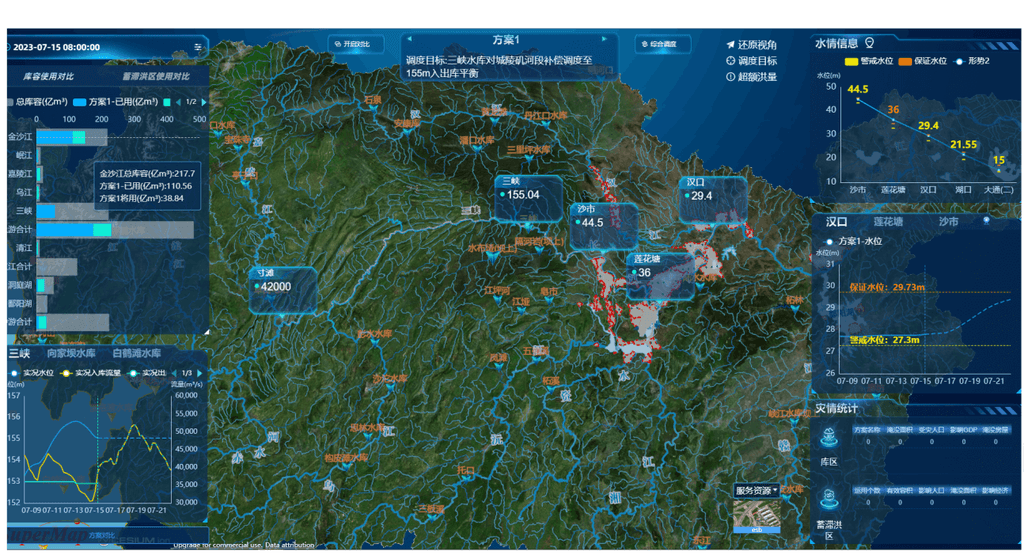
By integrating hydrological stations, video surveillance, remote sensing, mobile reporting, and emergency monitoring, the system creates a more comprehensive picture of water conditions across the basin.
The integrated architecture supports:
- Wide-area monitoring: Combining information from geographically distributed monitoring sites.
- Multi-source data integration: Bringing together hydrological measurements, video, remote sensing, and field reports.
- Real-time information access: Improving the availability of monitoring data for operational teams.
- Early warning and response: Supporting risk assessment, alerting, and emergency management workflows.
- Data-driven decision-making: Providing information to support water resource management and flood and drought disaster prevention.
Together, these capabilities contribute to the digitalization, network connectivity, and intelligent development of river basin monitoring and management.
4. The Role of Industrial RTUs and Data Acquisition Hardware
Large-scale digital twin water management systems depend on reliable field data collection and communication across distributed monitoring locations.
Industrial RTUs and data acquisition equipment can serve as field-level components for connecting compatible sensors and instruments to centralized monitoring platforms. Depending on system requirements, these devices may support sensor data acquisition, remote telemetry, industrial communication protocols, and integration with existing monitoring infrastructure.
Hu Entropy Tech provides industrial RTUs, vibrating wire data acquisition units, multi-channel acquisition equipment, and customized monitoring hardware for infrastructure and water-related monitoring applications.
Our hardware can be considered for suitable monitoring subsystems where sensor compatibility, communication requirements, and platform integration have been verified.
Looking for industrial data acquisition hardware for digital water management projects?
Contact Hu Entropy Tech to discuss your RTU, sensor interface, communication protocol, and OEM/ODM requirements.
Website: https://huentropytech.com/