
Non-Contact Monitoring for Slopes and Landslides
Remote Monitoring. Early Detection. Enhanced Slope Safety.
Hu Entropy Tech provides an integrated slope structural health monitoring solution designed for natural slopes, engineered slopes, and landslide-prone areas. Combining advanced vision-based displacement measurement, passive optical targets, solar-powered supply systems, wireless data transmission, and cloud-based monitoring, the solution enables continuous remote observation of slope movement and deformation.
Designed for challenging outdoor environments and geographically dispersed monitoring sites, the system helps engineers identify displacement trends, track deformation rates, and detect potential slope instability at an early stage.
By enabling remote multi-point monitoring over large areas, the solution reduces the need for frequent manual inspections and helps minimize personnel exposure to potentially hazardous slopes.
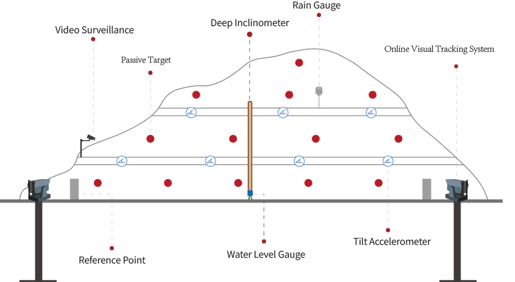
Key Monitoring Parameters:
Slope Displacement | Deformation Rate | Crack Opening
Typical Applications:
Highway & Railway Slopes | Open-Pit Mines | Reservoir Banks | Urban Slopes | Unstable Rock Masses
1. Non-Contact Vision-Based Slope Monitoring
Remote Multi-Point Measurement Over Large Areas
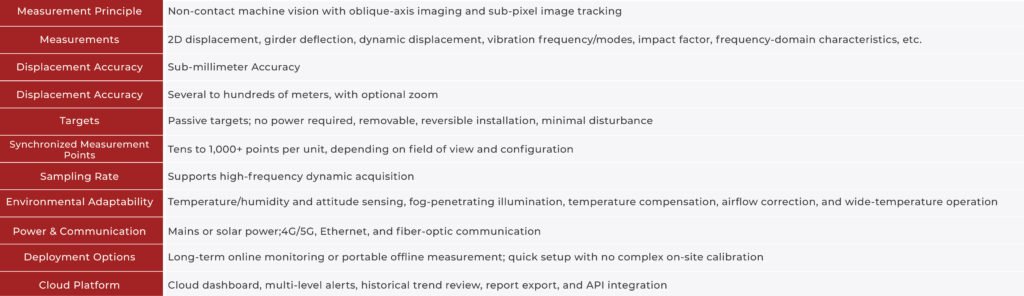
Based on oblique-axis imaging, Digital Image Correlation (DIC), and sub-pixel target recognition algorithms, the Online Visual Tracking System provides non-contact displacement measurement for slopes and unstable geological structures.
Passive optical targets are installed at selected locations across the monitored slope. The system continuously captures images, tracks target position changes, and calculates horizontal and vertical displacement without direct physical contact with the monitored terrain.
Multiple targets can be monitored simultaneously by a single visual tracking system, allowing engineers to observe movement across different sections of a slope from a safe distance.
Compared with conventional point-based monitoring approaches, the solution offers flexible multi-point visual measurement, simplified deployment, and reduced field wiring requirements.
Measurement data is transmitted wirelessly to the cloud platform for real-time visualization, deformation trend analysis, and configurable alarm notifications.
2. Key Features & Advantages
Remote Non-Contact Monitoring
Monitor slope displacement from a safe distance without requiring personnel to access potentially unstable areas.
Large-Area Multi-Point Measurement
Track multiple monitoring targets simultaneously, providing a broader view of slope movement and deformation patterns.
Solar-Powered Operation
Support solar-powered deployment for remote monitoring locations where grid electricity is unavailable or difficult to access.
Wireless Data Transmission
Transmit monitoring data to the cloud platform through wireless communication, reducing field cabling and simplifying installation.
Continuous Deformation Tracking
Automatically monitor displacement changes over time and analyze deformation trends to help identify potential instability.
Intelligent Alarm Notifications
Configure displacement thresholds and receive timely notifications when monitoring parameters exceed predefined limits.
Cloud-Based Remote Management
Access real-time measurements, historical data, deformation curves, and monitoring reports through a centralized cloud platform.
3. Integrated Slope Monitoring System Architecture
From Visual Sensing to Cloud-Based Early Warning
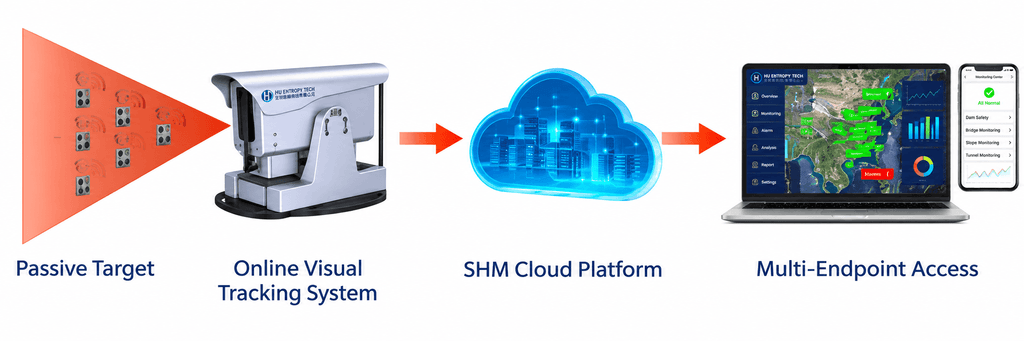
Passive Targets → Visual Tracking System → Solar Power & Wireless Communication → Cloud Platform → Deformation Analysis & Early Warning
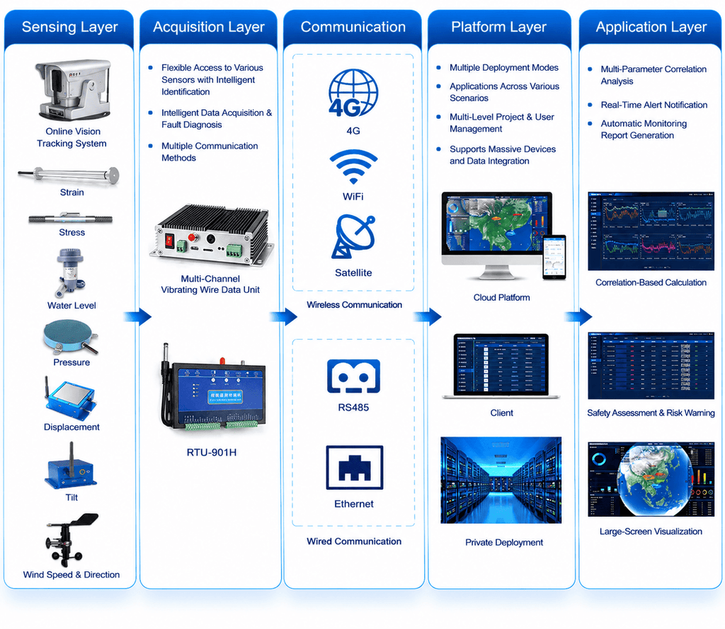
The integrated architecture combines vision-based displacement measurement, passive optical targets, solar power supply, wireless communication, and centralized cloud-based data management.
For projects requiring additional geotechnical measurements, the system can be integrated with conventional monitoring sensors and industrial RTU devices to collect multiple types of field data.
Supporting flexible wireless communication options, including 4G/5G, the system enables remote monitoring and centralized management across geographically dispersed slope monitoring locations.
Users can access real-time monitoring dashboards, review historical displacement trends, export monitoring reports, and integrate project data with third-party platforms through API interfaces.
4. Typical Applications
Highway & Railway Slopes
Monitor slope displacement and deformation along highways, railways, and transportation corridors to support infrastructure safety management.
Open-Pit Mines
Track movement of mine slopes and unstable rock masses, providing remote monitoring data for mine safety assessment.
Reservoir Banks
Monitor deformation and displacement along reservoir banks and surrounding slopes to support long-term stability assessment.
Urban & Construction Slopes
Monitor slopes affected by excavation, construction activities, and changes in surrounding ground conditions.
Landslide-Prone Areas
Continuously observe displacement at selected locations in potentially unstable geological areas to identify abnormal movement trends.
Unstable Rock Masses
Monitor movement and relative displacement of selected rock masses from a safe observation location, reducing the need for personnel to approach hazardous areas.
5. Smarter Remote Monitoring for Slope Safety
From highway and railway infrastructure to open-pit mines and landslide-prone areas, Hu Entropy Tech combines non-contact visual measurement, solar-powered deployment, wireless data transmission, and cloud-based monitoring to provide flexible slope monitoring solutions.
By enabling remote multi-point measurement across large monitoring areas, the system helps engineering teams improve site visibility, identify abnormal deformation trends, and make more informed decisions for slope safety management.
HU ENTROPY TECH
IoT Monitoring, Smarter Future.
Contact us to discuss your slope monitoring requirements and customized monitoring system solutions.
